
电子邮件: longtf@aircas.ac.cn
通信地址: 北京市海淀区邓庄南路9号
邮政编码: 100094
研究领域
遥感图像处理与应用、智能遥感信息挖掘、国产卫星数据定量化、森林-火烧迹地遥感制图、夜光遥感等
教育背景
2008-09--2011-07 中国科学院对地观测与数字地球科学中心 硕士
2004-09--2008-07 武汉大学 学士
工作经历
工作简历
2019-06~2020-12,中国科学院空天信息创新研究院, 助理研究员
2014-02~2019-06,中国科学院遥感与数字地球研究所, 助理研究员
2011-07~2014-01,中国科学院对地观测与数字地球科学中心, 研究实习员
社会兼职
2020-12-28-2021-12-27,《Remote Sensing》, Topic Editor, Guest Editor
专利与奖励
奖励信息
(2) 北京市科技进步奖, 二等奖, 省级, 2021
(3) 海南省科技进步奖, 二等奖, 省级, 2018
(4) 朱李月华优秀博士生奖学金, , 院级, 2016
(5) 北京市优秀毕业生, , 市地级, 2016
(6) 中国科学院大学优秀毕业生, , 院级, 2016
(7) 亚洲遥感会议最佳学生论文奖, , 其他, 2015
(8) 海南省科技进步奖, 一等奖, 省级, 2015
(9) 武汉大学优秀毕业生, , 研究所(学校), 2008
(10) 苏一光优秀学生奖学金, , 研究所(学校), 2006
专利成果
[2] 唐朝, 张兆明, 龙腾飞, 何国金, 彭燕, 王桂周. 一种基于注意力机制与全卷积孪生神经网络的矿区变化检测方法. CN: CN113505636A, 2021-10-15.
[3] 唐朝, 张兆明, 何国金, 彭燕, 龙腾飞, 王桂周. 一种改进的全卷积孪生神经网络的矿区变化检测方法. CN: CN113158770A, 2021-07-23.
[4] 刘永坤, 龙腾飞, 焦伟利, 何国金, 陈勃, 黄鹏. 一种遥感卫星影像的辐射校正方法及装置. 202110731534.1, 2021-06-30.
[5] 魏胜蓉, 焦伟利, 刘慧婵, 龙腾飞, 闭璐, 何国金. 国际空间站RGB夜间灯光图像的相对辐射归一化方法. CN: CN111680659A, 2020-09-18.
[6] 王猛猛, 何国金, 张兆明, 龙腾飞, 王桂周, 张晓美. 一种Landsat8热红外数据大气水汽含量反演方法. CN: CN105300880B, 2020-08-18.
[7] 江威, 龙腾飞, 庞治国, 何国金, 付俊娥. 一种基于Google Earth Engine云平台的地表水体产品生成方法和系统. ZL202010568232.2, 2020-06-09.
[8] 张兆明, 何国金, 王猛猛, 龙腾飞, 王桂周, 张晓美. 一种Landsat8卫星数据地表反射率反演方法. CN: CN105183989B, 2019-12-03.
[9] 董云云, 焦伟利, 龙腾飞. 一种新的基于深度学习的遥感影像配准方法. CN: CN109711444A, 2019-05-03.
[10] 申茜, 龙腾飞, 李利伟, 陈甫, 姚月, 杨旭, 七珂珂. 遥感影像处理方法及装置. CN: CN109118457A, 2019-01-01.
[11] 张兆明, 何国金, 王猛猛, 龙腾飞, 王桂周, 张晓美. 宽视域卫星影像地表反射率反演方法. 中国: CN104951656B, 2018.01.12.
[12] 龙腾飞, 焦伟利, 何国金, 张兆明. 基于1 1 范数约束的有理函数模型参数求解和全参数优化方法. 中国: CN104102844B, 2017-11-17.
[13] 张兆明, 何国金, 龙腾飞, 王猛猛, 王桂周, 张晓美. 一种实用的叶面积指数遥感反演方法. 中国: CN104899394B, 2017-10-10.
[14] 龙腾飞, 焦伟利, 何国金, 王威, 程博, 张兆明. 一种用于遥感影像几何校正的在线自动匹配方法. 中国: CN105160684A, 2015-12-16.
[15] 张兆明, 何国金, 王猛猛, 龙腾飞, 王桂周, 张晓美. 一种Landsat 8卫星数据地表温度反演方法. CN: CN104897289A, 2015-09-09.
[16] 张兆明, 何国金, 龙腾飞, 王猛猛. 一种耦合卫星遥感影像大气校正和地形校正过程的地表反射率获取技术. CN: CN104156567A, 2014-11-19.
[17] 龙腾飞, 焦伟利, 张兆明, 何国金. 卫星影像像元观测天顶角和方位角的计算方法. CN: CN104121884A, 2014-10-29.
[18] 龙腾飞, 焦伟利, 何国金, 张兆明. 基于1 1 范数约束的有理函数模型参数求解和全参数优化方法. CN: CN104102844A, 2014-10-15.
[19] 张兆明, 何国金, 王猛猛, 龙腾飞. 一种逐像元计算卫星遥感影像大气程辐射的物理方法. CN: CN104049256A, 2014-09-17.
[20] 龙腾飞, 焦伟利. 一种基于直线段的图像几何校正方法. CN: CN103177441A, 2013-06-26.
[21] 龙腾飞, 焦伟利. 一种基于嵌套回归的有理函数模型参数自动优选及求解方法. CN: CN102855221A, 2013-01-02.
[22] 龙腾飞, 焦伟利, 王威, 何国金. 基于面特征的图像几何校正方法. CN: CN102663680A, 2012-09-12.
[23] 龙腾飞, 焦伟利, 王威. 通用的多源遥感影像几何校正模型联合平差方法. CN: CN101907705A, 2010-12-08.
[24] 焦伟利, 何国金, 王威, 程博, 贾秀鹏, 项波, 刘慧婵, 张晓美, 陈朋山, 袁继颖, 李盈, 张京涛, 龙腾飞, 马应召, 张兆明, 孙颖, 陈立波, 张鑫, 刘远, 秦静, 刘复生, 王桂周, 张思龙, 王铎. 自动和稳健的卫星遥感影像正射校正方法. CN: CN101750606A, 2010-06-23.
出版信息
第一/通讯作者代表性论文如下:
Lin, Z., Long, T., Jiao, W., Ye, Z., Zhang, D., He, G., 2024. Estimation and spatiotemporal analysis of actual evapotranspiration over Qinghai-Tibet Plateau using an Alpine Grassland-Adapted Priestley-Taylor model. Journal of Hydrology 641, 131756. https://doi.org/10.1016/j.jhydrol.2024.131756
Liu, Y., Long, T., Jiao, W., Du, Y., He, G., Zhang, Z., Wang, G., Peng, Y., 2024. Single Satellite Image Sharpening with Any-angle 2D MTF Estimation. IEEE Trans. Geosci. Remote Sensing 1–1. https://doi.org/10.1109/TGRS.2024.3457906
Long, T., Jiao, W., He, G., Zhang, Z., Wang, G., 2024. Practical On-Orbit Geometric Recalibration of GF-1 WFV Images Based on RPC Model. IEEE Geosci. Remote Sensing Lett. 21, 1–5. https://doi.org/10.1109/LGRS.2024.3425849
Du, Y., He, X., Chen, L., Wang, D., Jiao, W., Liu, Y., He, G., Long, T., 2024. Improving Unsupervised Object-Based Change Detection via Hierarchical Multi-Scale Binary Partition Tree Segmentation: A Case Study in the Yellow River Source Region. Remote Sensing 16, 629. https://doi.org/10.3390/rs16040629
Gong, C., Long, T., Yin, R., Jiao, W., Wang, G., 2023. A hybrid algorithm with swin transformer and convolution for cloud detection. Remote Sensing 15, 5264. https://doi.org/10.3390/rs15215264
Liu, Y., Long, T., Jiao, W., Chen, B., Cheng, B., Du, Y., He, G., Huang, P., 2023a. Leveraging “Night–Day” Calibration Data to Correct Stripe Noise and Vignetting in SDGSAT-1 Nighttime-Light Images. IEEE Trans. Geosci. Remote Sens. 61, 1–23. https://doi.org/10.1109/TGRS.2023.3300257
Liu, Y., Long, T., Jiao, W., Du, Y., He, G., Chen, B., Huang, P., 2023b. Automatic segment-wise restoration for wide irregular stripe noise in SDGSAT-1 multispectral data using side-slither data. The Egyptian Journal of Remote Sensing and Space Sciences 26, 747–757. https://doi.org/10.1016/j.ejrs.2023.07.012
温春晖, 龙腾飞, 焦伟利, 林子镕, 刘永坤, 刘慧婵, 刘鸣, 何国金, 2023. 北京市典型居住区道路照明公众感知评价及模拟优化. 照明工程学报 34, 114–125.
龙腾飞, 焦伟利, 何国金, 王桂周, 张兆明, 2023. 国产光学卫星正射影像产品及自动生成算法. 遥感学报 27, 635–650. https://doi.org/10.11834/jrs.20232041
Liu, Y., Long, T., Jiao, W., He, G., Chen, B., Huang, P., 2022. A General Relative Radiometric Correction Method for Vignetting and Chromatic Aberration of Multiple CCDs: Take the Chinese Series of Gaofen Satellite Level-0 Images for Example. IEEE Trans. Geosci. Remote Sens. 60, 1–25. https://doi.org/10.1109/TGRS.2022.3141223
Long, T., Xu, Y., Zou, H., Lu, L., Yuan, T., Dong, Z., Dong, J., Ke, X., Ling, S., Ma, Y., 2022. A Generic Pixel Pitch Calibration Method for Fundus Camera via Automated ROI Extraction. Sens. 22, 8565. https://doi.org/10.3390/s22218565
Wei, M., Zhang, Z., Long, T., He, G., Wang, G., 2021. Monitoring Landsat Based Burned Area as an Indicator of Sustainable Development Goals. Earth’s Future 9. https://doi.org/10.1029/2020EF001960
Long, T., Jiao, W., He, G., Yin, R., Wang, G., Zhang, Z., 2020. Block Adjustment With Relaxed Constraints From Reference Images of Coarse Resolution. IEEE Trans. Geosci. Remote Sens. 58, 7815–7828. https://doi.org/10.1109/TGRS.2020.2984533
Zhang, Z., Long, T., He, G., Wei, M., Tang, C., Wang, W., Wang, G., She, W., Zhang, X., 2020. Study on Global Burned Forest Areas Based on Landsat Data. Photogramm. Eng. Remote Sens. 86, 503–508. https://doi.org/10.14358/PERS.86.8.503
Dong, Y., Jiao, W., Long, T., Liu, L., He, G., 2019a. Eliminating the Effect of Image Border with Image Periodic Decomposition for Phase Correlation Based Remote Sensing Image Registration. Sens. 19, 2329. https://doi.org/10.3390/s19102329
Dong, Y., Jiao, W., Long, T., Liu, L., He, G., Gong, C., Guo, Y., 2019b. Local Deep Descriptor for Remote Sensing Image Feature Matching. Remote Sensing 11, 430. https://doi.org/10.3390/rs11040430
Long, T., Zhang, Z., He, G., Jiao, W., Tang, C., Wu, B., Zhang, X., Wang, G., Yin, R., 2019. 30 m Resolution Global Annual Burned Area Mapping Based on Landsat Images and Google Earth Engine. Remote Sensing 11, 489. https://doi.org/10.3390/rs11050489
Dong, Y., Jiao, W., Long, T., He, G., Gong, C., 2018a. An Extension of Phase Correlation-Based Image Registration to Estimate Similarity Transform Using Multiple Polar Fourier Transform. Remote Sensing 10, 1719. https://doi.org/10.3390/rs10111719
Dong, Y., Long, T., Jiao, W., He, G., Zhang, Z., 2018b. A Novel Image Registration Method Based on Phase Correlation Using Low-Rank Matrix Factorization With Mixture of Gaussian. IEEE Trans. Geosci. Remote Sens. 56, 446–460. https://doi.org/10.1109/TGRS.2017.2749436
Jiang, W., He, G., Leng, W., Long, T., Wang, G., Liu, H., Peng, Y., Yin, R., Guo, H., 2018a. Characterizing Light Pollution Trends across Protected Areas in China Using Nighttime Light Remote Sensing Data. ISPRS International Journal of Geo-Information 7, 243. https://doi.org/10.3390/ijgi7070243
Jiang, W., He, G., Long, T., Guo, H., Yin, R., Leng, W., Liu, H., Wang, G., 2018b. Potentiality of Using Luojia 1-01 Nighttime Light Imagery to Investigate Artificial Light Pollution. Sens. 18, 2900. https://doi.org/10.3390/s18092900
Jiang, W., He, G., Long, T., Ni, Y., Liu, H., Peng, Y., Lv, K., Wang, G., 2018c. Multilayer Perceptron Neural Network for Surface Water Extraction in Landsat 8 OLI Satellite Images. Remote Sensing 10, 755. https://doi.org/10.3390/rs10050755
Jiang, W., He, G., Long, T., Liu, H., 2017. Ongoing Conflict Makes Yemen Dark: From the Perspective of Nighttime Light. Remote Sensing 9, 798. https://doi.org/10.3390/rs9080798
Long, T., Jiao, W., He, G., Zhang, Z., 2016. A Fast and Reliable Matching Method for Automated Georeferencing of Remotely-Sensed Imagery. Remote Sensing 8, 56. https://doi.org/10.3390/rs8010056
Long, T., Jiao, W., He, G., 2015a. RPC Estimation via l1-Norm-Regularized Least Squares (L1LS). IEEE Trans. Geosci. Remote Sens. 53, 4554–4567. https://doi.org/10.1109/TGRS.2015.2401602
Long, T., Jiao, W., He, G., Zhang, Z., Cheng, B., Wang, W., 2015b. A generic framework for image rectification using multiple types of feature. Isprs J. Photogramm. Remote Sens. 102, 161–171. https://doi.org/10.1016/j.isprsjprs.2015.01.015
Long, T., Jiao, W., He, G., 2014a. Nested Regression Based Optimal Selection (NRBOS) of Rational Polynomial Coefficients. Photogramm. Eng. Remote Sens. 80, 261–269. https://doi.org/10.14358/PERS.80.3.261
Long, T., Jiao, W., He, G., Wang, W., 2014b. Automatic Line Segment Registration Using Gaussian Mixture Model and Expectation-Maximization Algorithm. IEEE J. Sel. Topics Appl. Earth Observ. Remote Sens. 7, 1688–1699. https://doi.org/10.1109/JSTARS.2013.2273871
龙腾飞, 焦伟利, 王威, 2013. 基于面特征的遥感图像几何校正模型. 测绘学报 42, 540–545.
发表著作
(2) 武汉城市群城市化及其生态环境效应, 科学出版社, 2017-06, 第 2 作者
(3) 全球生态环境遥感监测 2019 年度报告(全球森林覆盖及变化), 科学出版社, 2019-12, 第 其他 作者
(4) 遥感信息工程, 科学出版社, 2020-12, 第 3 作者
科研项目
( 2 ) 基于新型泛化模型的超大幅宽卫星影像快速高精度几何处理技术研究, 负责人, 研究所科学与颠覆性技术研究先导基金, 2023-06--2025-05
( 3 ) 青年创新促进会, 负责人, 中国科学院人才项目, 2019-01--2022-12
( 4 ) 基于松弛约束的卫星影像序列多特征地面无控协同定位, 负责人, 自然科学基金青年项目, 2018-01--2020-12
( 5 ) 30m分辨率全球多源卫星数据定量化处理, 负责人, 国家重点研发计划子课题, 2016-01--2021-12
( 6 ) 基于认知计算的遥感卫星下行数据即时服务的理论与方法研究, 几何技术负责人, 自然科学基金重点项目, 2018-01--2022-12
( 7 ) 地球大数据科学工程——CASEarth DataBank 系统建设, 主任设计师, A类先导专项, 2018-01--2022-12
( 8 ) 第二次青藏高原综合科学考察研究-生态系统特征参数遥感反演, 副组长, 国家任务, 2019-01--2024-12
( 9 ) 全时序地表反射率地理格网RTU产品研制, 负责人, 中国科学院计划, 2021-01--2021-12
全球火烧迹地制图
提出基于Landsat系列卫星数据的全球火烧迹地自动制图方法,结合长时间序列的多源卫星遥感数据,通过利用全球火烧迹地和非火烧迹地样本库和基于生态系统分区的机器学习方法,实现了全球30米分辨率火烧迹地产品的快速高精度生产。研发了国际首套长时序全球30米分辨率火烧迹地产品(GABAM,2000-2021),是目前最高空间分辨率的全球火烧迹地产品,比现有国际同类产品空间分辨率高出一个数量级,实现全球火灾的精准监测。
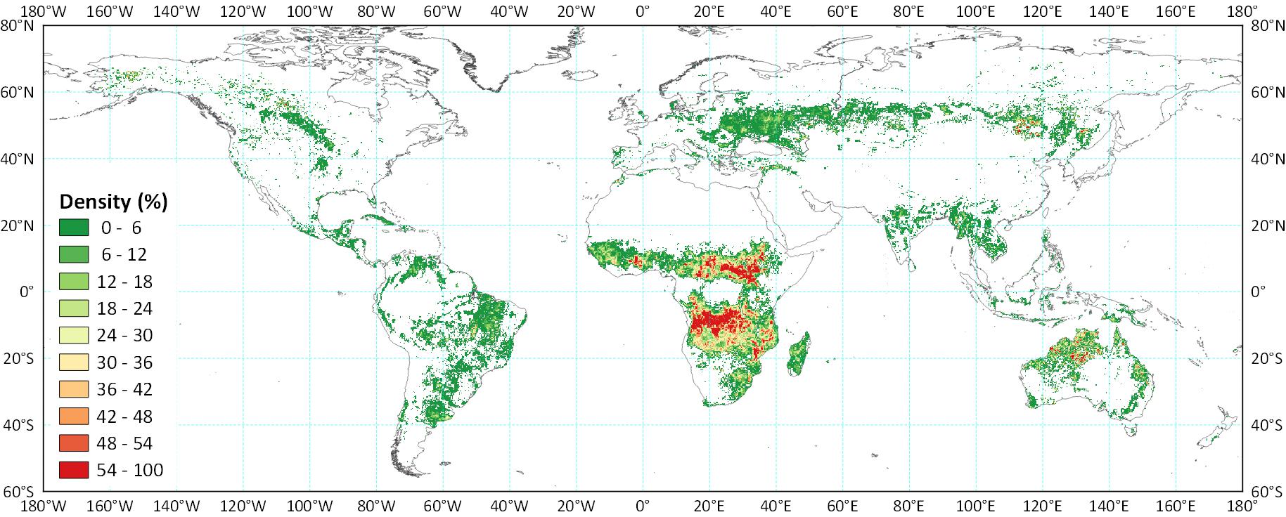
GABAM 2015
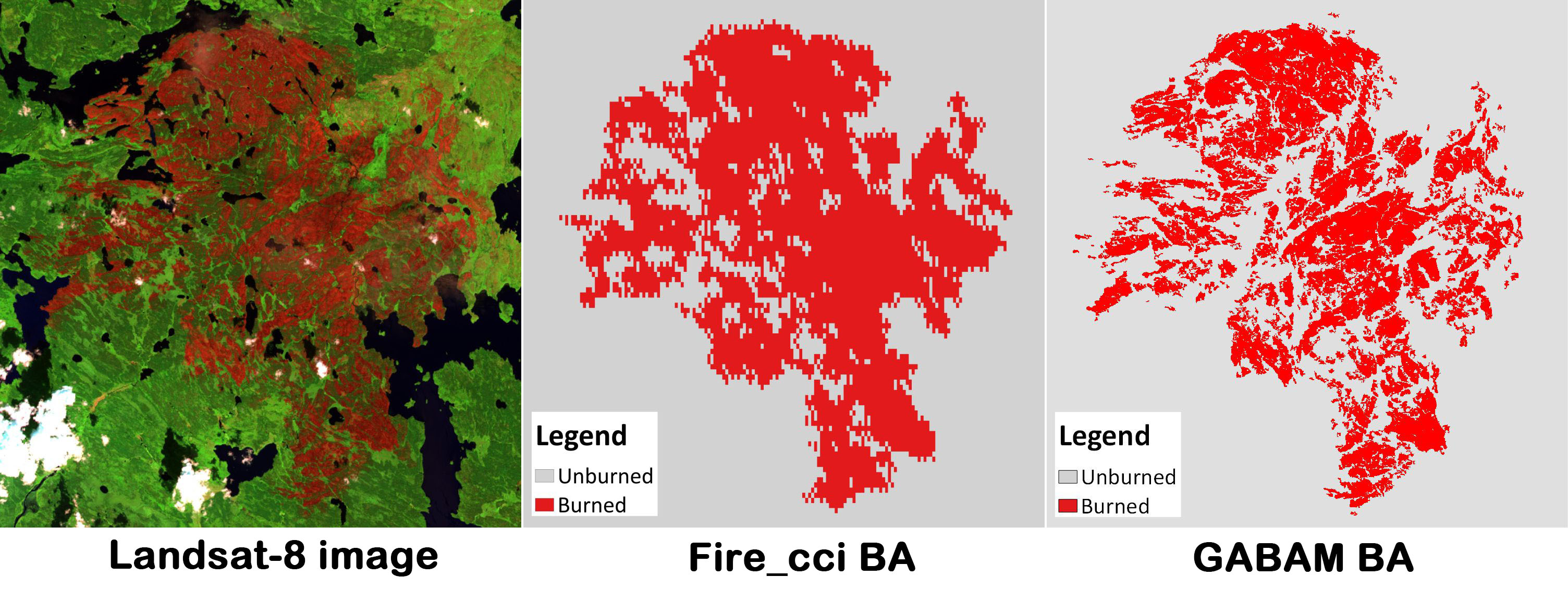
与Fire_cci产品(其它最高分辨率全球火烧迹地产品)对比
产品链接:https://vapd.gitlab.io/post/gabam/
Long, T.; Zhang, Z.; He, G.; Jiao, W.; Tang, C.; Wu, B.; Zhang, X.; Wang, G.; Yin, R. 30 m Resolution Global Annual Burned Area Mapping Based on Landsat Images and Google Earth Engine. Remote Sens. 2019, 11, 489.
指导学生
现指导学生
温春晖 硕士研究生 085700-资源与环境
王龙飞 硕士研究生 070503-地图学与地理信息系统
冶龙 硕士研究生 085700-资源与环境