
万雪 女 硕导 中国科学院空间应用工程与技术中心
电子邮件: wanxue@csu.ac.cn
通信地址: 北京市海淀区邓庄南路9号
邮政编码:
电子邮件: wanxue@csu.ac.cn
通信地址: 北京市海淀区邓庄南路9号
邮政编码:
研究领域
研究方向概述
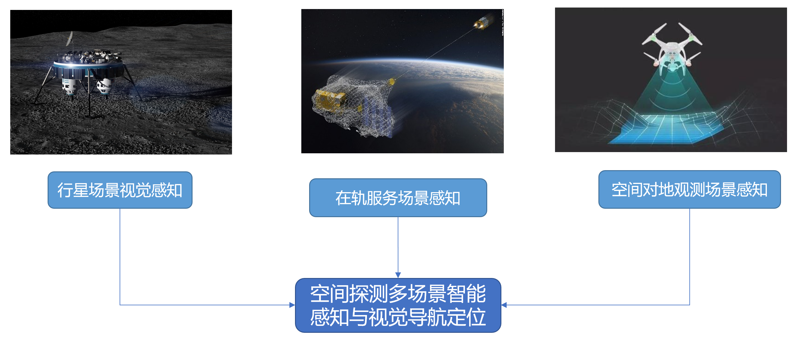
行星场景感知与视觉导航定位

项目介绍:
研究团队针对地面移动平台开发了基于双目视觉、基于激光雷达地面机器人自主导航软件系统,导航软件可在快速双目视觉、视觉加惯导、激光导航三种模式间切换,实现机器人在模拟行星环境下基于多传感器融合的建图、导航及避障,满足不同导航应用需求可自动切换选择不同的导航匹配算法及对应优化策略。

项目介绍:
研究团队完成了基于地形匹配的火星无人机视觉导航定位算法,比基线方法精度提升了65.6%
项目介绍:
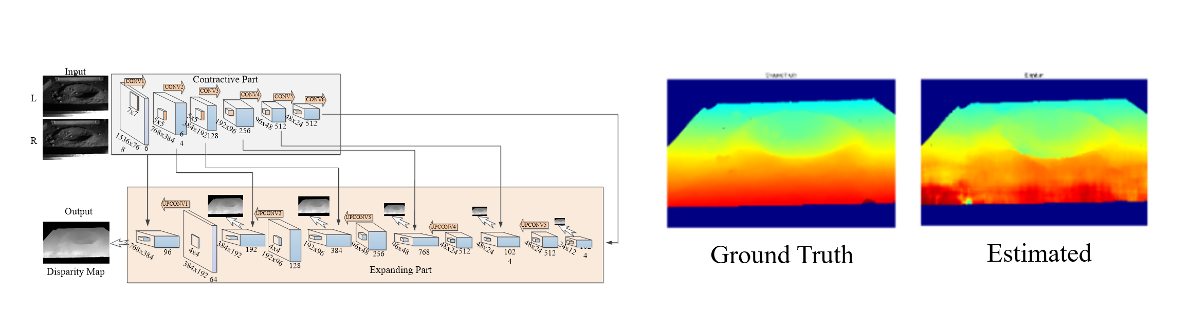
完成了基于深度学习的月球坑三维重建,对于低纹理、遮挡区域等区域较传统方法精度更高
空间目标感知与追踪

项目介绍:
提出STAS框架,将深度卷积特征同时用于目标跟踪与分割,实现复杂场景下空间目标自动识别与跟踪,解决翻滚、遮挡等问题

项目介绍:
构建空间目标三维部件分割数据集,提出基于三维点云的部件识别网络,识别准确率高于90%,识别速度小于0.5s
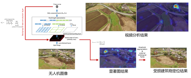
空间对地观测场景感知
项目介绍:
针对无人机大场景村镇灾害场景的受损建筑物快速提取需求,提出基于Grad-CAM的弱监督定位模型,为灾害快速评估提供决策支持
招生信息
每年招收硕士研究生1-2名,欢迎有意加入中科院读研的同学!
招生专业
081203-计算机应用技术
招生方向
空间智能视觉、三维重建、SLAM
计算机视觉,信号处理
计算机视觉,信号处理
教育背景
2012-10--2015-12 伦敦帝国理工学院 理学博士
2010-10--2012-06 武汉大学遥感信息工程学院 工学硕士
2006-10--2010-06 武汉大学遥感信息工程学院 工学学士
2010-10--2012-06 武汉大学遥感信息工程学院 工学硕士
2006-10--2010-06 武汉大学遥感信息工程学院 工学学士
工作经历
工作简历
2015-12~2017-11,伦敦帝国理工学院, 助理研究员
社会兼职
2012-12-19-2017-02-20,GRSG委员会, 学生代表
教授课程
航天航空智能图像处理
出版信息
发表论文
[1] 邵亚东, 万雪, 武奥迪, 李盛阳, 舒磊正, 邵远斌, 霍君言. Satellite Component Semantic Segmentation: Video Dataset and Real-Time Pyramid Attention and Decoupled Attention Network. IEEE TRANSACTIONS ON AEROSPACE AND ELECTRONIC SYSTEMS[J]. 2023, [2] 柯涛, 牛壮群, 陶鹏杰, 徐景中, 余洋, 万雪, 郑学东, 王国新, 段延松, 杜娟. 村镇建筑时空一体化防灾监测理论体系研究与应用. 测绘地理信息[J]. 2023, 48(2): 1-7, http://lib.cqvip.com/Qikan/Article/Detail?id=7109492196.
[3] 邵亚东, 邵远斌, 武奥迪, 万雪. 航天器部件的精细分割和稳定跟踪. 光学精密工程[J]. 2023, 31(22): 3383-3394, http://sciencechina.cn/gw.jsp?action=detail.jsp&internal_id=7597483&detailType=1.
[4] 张碧辉, 万雪, 舒磊正. Robust GNSS-Visual-Inertial Odometry with Outlier Exclusion and Sensor’s Failure Handling. ICICT2023null. 2023, [5] 李盛阳, 韩鸣飞, 万雪, 轩诗宇, 赵子飞. 融合特征的卫星视频车辆单目标跟踪方法. 中国图象图形学报[J]. 2021, [6] 孙运达, 万雪, 李盛阳. 基于孪生网络的航天器部件追踪. 光学精密工程[J]. 2021, 29(12): 2915-2923, http://lib.cqvip.com/Qikan/Article/Detail?id=7106441813.
[7] 李沛卓, 万雪, 李盛阳. 基于多模态学习的空间科学实验图像描述. 光学精密工程[J]. 2021, 29(12): 2944-2955, http://lib.cqvip.com/Qikan/Article/Detail?id=7106441816.
[8] K Liu, A Wu, X Wan, S Li. MRSSC: A BENCHMARK DATASET FOR MULTIMODAL REMOTE SENSING SCENE CLASSIFICATION. THE INTERNATIONAL ARCHIVES OF THE PHOTOGRAMMETRY[J]. 2021, 785-792, https://doaj.org/article/58e5bdf6ff864480be22b7194d035329.
[9] 韩鸣飞, 李盛阳, 万雪, 轩诗宇, 赵子飞, 谭洪, 张万峰. 融合特征的卫星视频车辆单目标跟踪. 中国图象图形学报[J]. 2021, 26(11): 2741-2750, http://lib.cqvip.com/Qikan/Article/Detail?id=7106193311.
[10] Jia, Qingling, Wan, Xue, Hei, Baoqin, Li, Shengyang. A new disparity map quality assessment based on structural similarity for remotely sensed image pairs. REMOTE SENSING LETTERS[J]. 2020, 11(7): 659-666, [11] Xuan, Shiyu, Li, Shengyang, Han, Mingfei, Wan, Xue, Xia, GuiSong. Object Tracking in Satellite Videos by Improved Correlation Filters With Motion Estimations. IEEE TRANSACTIONS ON GEOSCIENCE AND REMOTE SENSING[J]. 2020, 58(2): 1074-1086, http://dx.doi.org/10.1109/TGRS.2019.2943366.
[12] 覃帮勇, 万雪, 轩诗宇, 李盛阳, 刘康. “一带一路”沿线港口城市天宫二号多光谱影像数据集. 遥感学报[J]. 2020, 24(9): 1088-1098, http://lib.cqvip.com/Qikan/Article/Detail?id=7102803598.
[13] Xu Huang, Xue Wan, Daifeng Peng. Robust Feature Matching with Spatial Smoothness Constraints. REMOTE SENSING[J]. 2020, 12(19): https://doaj.org/article/be9595b3049d45dabaa9ded735c76359.
[14] Wan, Xue, Liu, Jian Guo, Li, Shengyang, Yan, Hongshi. Phase Correlation Decomposition: The Impact of Illumination Variation for Robust Subpixel Remotely Sensed Image Matching. IEEE TRANSACTIONS ON GEOSCIENCE AND REMOTE SENSING[J]. 2019, 57(9): 6710-6725, http://dx.doi.org/10.1109/TGRS.2019.2907933.
[15] 万雪. Deep Learning Network Integrated Multi-spectral Data and Interferometric Imaging Radar Altimeter Data of Tiangong-2 for Land Use Classification. Proceedings of the Tiangong-2 Remote Sensing Application Conference. 2019, [16] 万雪. Object-Based Classification from Tiangong-2 Using Support Vector Machine Optimized with Evolutionary Algorithm. Proceedings of the Tiangong-2 Remote Sensing Application Conference. 2019, [17] Wan, Xue, Liu, Jianguo, Li, Shengyang, Dawson, John, Yan, Hongshi. An Illumination-Invariant Change Detection Method Based on Disparity Saliency Map for Multitemporal Optical Remotely Sensed Images. IEEE TRANSACTIONS ON GEOSCIENCE AND REMOTE SENSING[J]. 2019, 57(3): 1311-1324, https://www.webofscience.com/wos/woscc/full-record/WOS:000460321300007.
[18] Xue Wan, Chenhui Wang, Shengyang Li. The Extension of Phase Correlation to Image Perspective Distortions Based on Particle Swarm Optimization. SENSORS[J]. 2019, 19(14): https://doaj.org/article/a84f7bebbcae4d2a87c78f8c442431e8.
[19] Li, Peizhuo, Sun, Yunda, Wan, Xue, ACM. Saliency and Tracking based Semi-supervised Learning for Orbiting Satellite Segmentation. ICVIP 2019: PROCEEDINGS OF 2019 3RD INTERNATIONAL CONFERENCE ON VIDEO AND IMAGE PROCESSINGnull. 2019, 90-94, [20] Nicholas E Durston, Xue Wan, Jian G Liu, Shane P Windsor. Avian surface reconstruction in free flight with application to flight stability analysis of a barn owl and peregrine falcon. THE JOURNAL OF EXPERIMENTAL BIOLOGY[J]. 2019, 222(Pt 9): [21] M Qin, X Wan, Y Y Shao, S Y Li. AN AUTONOMOUS GPS-DENIED UNMANNED VEHICLE PLATFORM BASED ON BINOCULAR VISION FOR PLANETARY EXPLORATION. THEINTERNATIONALARCHIVESOFTHEPHOTOGRAMMETRY[J]. 2018, https://doaj.org/article/87754e2497a34cd1ad6b7fcd51940c31.
[22] Qin Man, Wan Xue, Shao YuYang, Li ShengYang, IEEE. The comparison between FTF-VO and MF-VO for high accuracy mobile robot localization. 2018 INTERNATIONAL CONFERENCE ON ROBOTS & INTELLIGENT SYSTEM (ICRIS 2018)null. 2018, 48-51, [23] X Wan, J Liu, M Qin, S Y Li. ILLUMINATION INVARIANT CHANGE DETECTION (IICD): FROM EARTH TO MARS. THE INTERNATIONAL ARCHIVES OF THE PHOTOGRAMMETRY[J]. 2018, https://doaj.org/article/b8fd4b4ed2f14538af23e23b73711d80.
[24] Han, Mingfei, Li, Shengyang, Wan, Xue, Liu, Guiyang, IEEE. Scene Recognition with Convolutional Residual Features via Deep Forest. 2018 IEEE 3RD INTERNATIONAL CONFERENCE ON IMAGE, VISION AND COMPUTING (ICIVC)null. 2018, 178-182, http://apps.webofknowledge.com/CitedFullRecord.do?product=UA&colName=WOS&SID=5CCFccWmJJRAuMzNPjj&search_mode=CitedFullRecord&isickref=WOS:000448170000035.
[25] Wan, Xue, Liu, Jianguo, Yan, Hongshi, Morgan, Gareth L K. Illumination-invariant image matching for autonomous UAV localisation based on optical sensing. ISPRS JOURNAL OF PHOTOGRAMMETRY AND REMOTE SENSING[J]. 2016, 119: 198-213, http://dx.doi.org/10.1016/j.isprsjprs.2016.05.016.
[26] 万雪. 3D Super Resolution Scene Depth Reconstruction Based on SkySat Video Image Sequences. IGARSS. 2016, [27] 万雪. Automatic Mars Rover Detection Based On Multi-Temporal HiRise Imagery. IGARSS. 2015, [28] Wan, Xue, Liu, Jian Guo, Yan, Hongshi. The Illumination Robustness of Phase Correlation for Image Alignment. IEEE TRANSACTIONS ON GEOSCIENCE AND REMOTE SENSING[J]. 2015, 53(10): 5746-5759, http://dx.doi.org/10.1109/TGRS.2015.2429740.
[29] 万雪. Phase Correlation based Local Illumination-invariant Method for Multi-Temporal Remote Sensing Image Matching. ISPRS-International Archives of the Photogrammetry, Remote Sensing and Spatial Information Sciences. 2014, [30] 万雪, 张祖勋, 柯涛. 一种利用零交叉点理论的改进SIFT特征提取算法. 武汉大学学报. 信息科学版[J]. 2013, 38(3): 270-273,286, http://sciencechina.cn/gw.jsp?action=detail.jsp&internal_id=4770053&detailType=1.
[31] 万雪. Generalized Point Photogrammetry Feature Extraction Based on Harris Operator and Vectorization. Geomatics and Information Science of Wuhan University. 2012, [32] X Wan, Z Zhang, Y Wan. AN IMPROVED ALGORITHM USED IN AUTOMATIC MATCHING FOR LOW-ALTITUDE AERIAL IMAGE. THE INTERNATIONAL ARCHIVES OF THE PHOTOGRAMMETRY[J]. 2012, 183-188, https://doaj.org/article/75d2a96c98e04df2b5838102e1823457.
[33] 万雪. Change Detection for Landuse in City Based on NDVI. GEOSPATIALINFORMATION. 2009, [34] []. PHOTOGRAMMETRIC TECHNIQUES FOR POWER LINE RANGING\n. 第30届亚洲遥感会议论文集\n.
科研活动
科研项目
( 1 ) 基于新一代视觉传感器的厘米级太空碎片快速感知、定位及追踪技术, 主持, 市地级, 2017-12--2018-12
( 2 ) 中科院高端人才中科院匹配经费, 主持, 部委级, 2018-01--2022-12
( 3 ) 中科院高端人才空间应用工程与技术中心匹配经费, 主持, 市地级, 2018-01--2018-12
( 4 ) 基于图像相位相关的地外行星探测器导航定位方法研究, 主持, 国家级, 2019-01--2021-12
( 5 ) 村镇灾后信息快速提取与识别, 主持, 国家级, 2018-12--2022-01
( 6 ) 空间目标智能感知, 主持, 部委级, 2019-01--2021-12
( 7 ) 空间科学与应用图像数据语义分类与场景识别, 主持, 市地级, 2018-12--2020-12
参与会议
(1)PC based Dense Matching and Super Resolution Scene Depth Reconstruction 2016-09-10
(2)3D Super Resolution Scene Depth Reconstruction Based on SkySat Video Image Sequences 2016-07-14
(3)High resolution three-dimensional surface measurements of birds of prey in gliding flight 2016-07-04
(4)Automatic Mars Rover Detection Based On Multi-Temporal HiRise Imagery 2015-07-13
(5)Illumination insensitive image matching for terrain related applications 2014-12-15
(6)Phase Correlation based Local Illumination-invariant Method for Multi-Temporal Remote Sensing Image Matching 2014-08-10
指导学生
已指导学生
李沛卓 硕士研究生 085211-计算机技术
孙运达 硕士研究生 081203-计算机应用技术
现指导学生
林泽楠 硕士研究生 085211-计算机技术
赵广源 硕士研究生 081203-计算机应用技术
武奥迪 硕士研究生 081203-计算机应用技术
邵亚东 博士研究生 081203-计算机应用技术
邵远斌 硕士研究生 081203-计算机应用技术
田瑶琳 硕士研究生 081203-计算机应用技术
刘佳宜 硕士研究生 081002-信号与信息处理